
Wild Lilac in full bloom on the Iron Mountain Hike
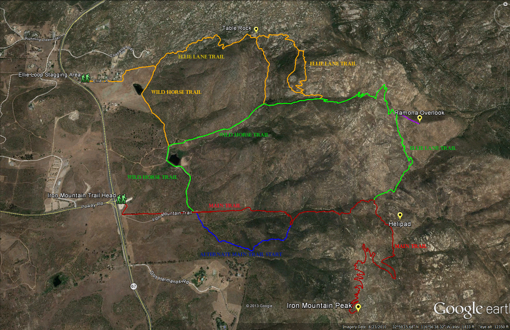
Trail Map of Iron Mountain Area
Main Iron Mountain Trail Distance: 5.8 miles. Elevation Gain: 1067 feet. Time to complete: 2-3 hours
Wild Horse Trail to Iron Mountain Trail Distance: 8.51 Miles. Elevation Gain & Lost: 2,601 feet. Time to complete: 3 – 4 hours.
Wild Horse Trail to Ellie Lane Loop to Iron Mountain Peak: 10.38 Miles. Elevation Gain and Lost: 3,533 Feet. Time to complete: 4-5 hours.
The Red Line is the Main Trail
The Green Line is the Wild Horse Loop
The Yellow Line is the Ellie Lane Loop
The Blue Line is just an alternative part of the main trail
The Purple line is the Ramona Overlook off of the Ellie Lane Loop.
How to get to the trail head:
From the 15 north or south, get off on the Poway Road Exit, and take Poway Road East all the way through Poway and up the hill until it ends at Highway 67. Directly across from that point will be the trail head for Iron Mountain.
Is this trail dog friendly ? That really depends on the weather and what time of day you take your pouch. I’ve had a lot of fun taking my dogs up this trail, but its been either in cold temperatures ( frozen puddles), or towards the end of the day when its cooling down. Remember to bring lots of water for YOU and your DOG! I’ve also seen a lot of coyote scat ( especially on Ellie Lane because its less traveled) so really keep an eye on your dog towards dusk.
Is this trail kid friendly? Well there are bathrooms at the trail head, and I have seen a lot of kids on this trail before, but if your kids have not been hiking before and or don’t like to hike then I would not recommend starting them on this hike.
Bathrooms ? The only bathrooms are at the main trail head, there are also trash cans there, but there is no water, so make sure you bring as much water as your going to need.
For the main trail start at the Main Trail Head and head out under the ranch style sign and foot bridge. You’ll mender through a long grove of shady trees at the start of the trail, ( enjoy it while you can, there is not much shade as you go up this hike). You will head up a long dusty rocky trail that you can see along for quite some way. Along this trail at about .4 miles you should see the trail split left to go towards the Ellie Lane loop or right to go up the alternative trail for the lower 3rd of the hike, you can go the main trail or the alternative it doesn’t really matter, the alternative trail connects back into the main trail, it goes trough more scrub brush and its kind of nice because its not so straight. If you go up the straight way the main trail will go along some pretty rocky terrain before it dips down going trough some shady creek bed and then back up the hill for a nice steep climb. It will even off for a little bit as you continue to ascend, and then you are in for more really rocky terrain, so watch your footing. You will find that the hardest points on the hike are this section and the last 4th of the trail. After you get through the rocky areas the trail will even off again and you will quickly reach the large trail split. At the trail split you will see a clearing defined sign with arrows and mileage for which ever way you decide to go. If you go left you head out on the Ellie Lane loop, if you want to go the Iron Mountain Peak go right.
After you go right to head up towards the Iron Mountain Peak you will find the trail pretty easy for the next 15-20 minutes or so, there are long gentle switch backs. You will first pass by the Heliport on your left side ( good to know in case of trouble), you’ll mender around through some brush and then up a short steep hill and along the meandering long switch backs. Since this is the backside of the mountain you will find that you don’t have much of a breeze back here. But not to worry just as the trail starts to get harder you will get to the crest of the trail ( where you can see both the backside and front side of the mountain and you’ll start feeling a nice breeze again. After the crest is when the switch backs start to get shorter and the hike gets a little harder, but not to worry your not that far from the top. Once you get up there, take in the views and there are couple of picnic tables to sit back and relax on. There is also a mounted telescope if you want to check things out, I was able to use the camera on my iPhone to snap of a pic or two through the telescope. If you look north you should see Mt Woodson, its the peak with all the antennas on top. If you like Iron Mountain, and are ready for a little more of a challenge try Mt Woodson. If you look south east you will see El Cajon Mountain, El Cajon Mountain makes this hike look like a warm up!
The Wild Horse Loop Trail starts at about .4 miles up the main trail, at .4 miles the main trail will have a trail on the left ( Wild Horse Trail) and a trail on your right ( alternative trail to the main trail up to the peak), take a left and head north on that trail. You will pass by a pond, ( which was dry as a bone when I went last) and then come to another trail split that will say Wild Horse trail at about .79 miles, take a right here and head up towards the canyon. You will see some improvised trails along the way, I just stayed on the trail where I could see the signs. At about .90 miles you should see a sign for The Old Miners Trail, take a right and head that way up the canyon. At about .99 miles the trail starts to ascend through the canyon. You will see a nice little creek bed down towards your right side as you head up the trail. Towards the top of the canyon you will see a grove of trees. When you get to the grove of trees you will see another trail towards your left, this is the Ellie Lane loop that takes off from the Ellie Lane Trail head. Take a right go through a tiny creek bed and head up the next canyon. At about 1.48 miles you start to ascended through the canyon again. As you go up through the canyon, you will see a smaller trail on the opposite side, this is part of the Ellie Lane loop trail from the trail head and connects back into the trail you are on just before the 2.0 mile marker. At 2.30 miles you will hit the trail crest and see down the backside of the mountain. Be careful here, we thought we were following the trail and it ended up being a little trail people had made over time that went nowhere. Meander down the backside of the trail and you will eventually come to the Ramona Overlook at 2.77 miles, ( even though the sign says 2.5, I think its counting the mileage from the trail head), you might as well take the Ramona Overlook Trail while your back here, it only adds 2/10 of a mile to the hike, and you get a really cool view. When you are done looking at the view head back to the main trail and take a left and head towards the Iron Mountain Peak. Along the way I noticed a lot more coyote scat on these backside trails then I have seen on the main trails, which makes me think that if your bringing any dogs on this hike to be aware of your surroundings. At about 3.77 miles you will hit the Main Trail Split. You can take a right and head back down to the Main Trail Head 1.45 miles, or continue on towards the Iron Mountain Peak also 1.45 miles more.
The Wild Horse to Ellie Lane Trail to Iron Mountain Peak via the Main Trail Loop starts at the starts at about .4 miles up the main trail, at .4 miles the main trail will have a trail on the left ( Wild Horse Trail) and a trail on your right ( alternative trail to the main trail up to the peak), take a left and head north on that trail. You will pass by a pond and then see the Wild Horse Sign before a little hill, take a right and skirt along the north side of the pond and around the hill and you will see the sign pointing you towards Ellie Lane, follow that sign down a little hill and past a wide open pasture. As you get to the end of the pasture you should be able to see the Ellie Lane trail head towards Highway 67. As you head along the trial you will see some house’s ahead up on a hill and the trail will connect up with Ellie Lane below and to the right of last large house. Head up the steps and connect in with Ellie Lane trail.
Weather forecast for the hike:
[forecast location="92064" caption="Weather for Iron Mountain Hike" measurement='F' todaylabel="Today" datelabel="(%%weekday%%)"highlow='%%high%%°/%%low%%°' numdays="5" iconset="Contemporary" cache="true" width="100%"]


