
Heading up the trail to the Sierra Club Ski Hut along the way to Mt Baldy Summit
Distance: 11.3 Mile Loop. Elevation Gain: 3900 feet. Time to complete: 6-8 hours
The Ascent to the top
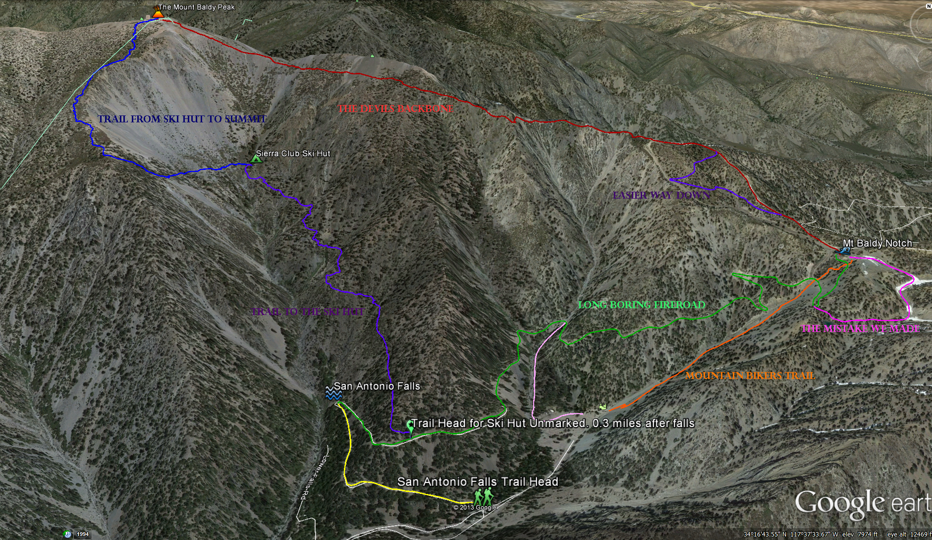
San Antonio Falls Parking area to San Antonio Falls : Distance 0.6 miles; Elevation change of 240 feet, from 6,160 to 6,400
San Antonio Falls to Ski Hut: Distance 1.9 miles; Elevation change of 1,810 feet, from 6,400 to 8,210
Ski Hut to the top of Mount Baldy: Distance 2.1 miles; Elevation change of 1,854 feet, from 8,210 to 10,064
The Descent to the bottom
Devils BackBone trail from the top of Mt Baldy to “The Notch”: Distance 3.2 Miles; Elevation change of 2,262 feet, from 10,064 down to 7,802
“The Baldy Notch” down to San Antonio Falls via Fire road: Distance 3.0 miles; Elevation change of 1,402 feet from 7,802 down to 6,400
San Antonio Falls down to the San Antonio Falls Parking area: Distance 0.6 miles; Elevation change of 240 feet , from 6,400 down to 6,160
Mt Baldy Hiking Trails
Getting there: Take the Monte Vista Ave exit off of the 10 freeway or the Padua Ave exit off of the 210 freeway, it doesn’t matter which one because they are both the same road. Head east toward the mountain, at the end of Padua Ave turn right and head south east on Mt Baldy Rd. Head into the mountains for about 10 miles, through the Mt Baldy Village until the road almost ends, you will see the trail head for Icehouse Canyon ahead, turn left here and continue up the extremely windy 2 mile section towards Mt Baldy ski area. Just before the ski area you should see the trailhead for the San Antonio Falls, the beginning of the hike.
Which way to hike: Clockwise or counter clockwise?. This all depends on how hard you want the hike to be. If you head counter clockwise you can take the ski lift (open on the weekends for $20) up to the “Baldy Notch” negating 3 miles of dirt fire road and 1600 feet of elevation gain at which point your hike becomes 6.6 miles round trip going back the way you came with 2,350 feet of elevation gain, the easiest way. You can also hike the dirt road up which is long and boring to the “Baldy Notch” and then to Devils backbone to the top and then back down past the skit hut towards the bottom, but my opinion is that the dirt road is boring and is better left for the end of your hike when your tired anyways, so my opinion is to head clockwise from the falls up towards the ski hut, then onto the summit and then back down devils backbone to the “Notch” and then back down the boring road to the bottom, but I warn you, the ascent can get pretty steep in some places and will challenge you.
Heading up the trail from San Antonio falls past the ski hut, towards the summit and then back down devils backbone to the “Notch” before heading down the dirt road.
After finding a parking spot somewhere along the side of the road next the to San Antonio Falls trailhead, put your Adventure Pass in your windshield and then head up the trail towards the falls, its only a short 0.6 miles and not that hard of a trail. It was pretty dry when we went at the end of August and there was only a trickle of water come over the falls even though it had rained the night before, I’m sure its prettier in different parts of the season. After the falls keep heading up the road for about 0.3 miles. Keep your eyes open, there is no sign for this trail, in fact the whole trail system on this hike is badly marked. The trail is on the left side of the road and right away your steep ascent starts, 1,800 feet in less then 2 miles. As you head up the trail enjoy the beautiful views of the valley behind you. Once your on the trail to the ski hut, even though its not marked extremely well there is not much chance of you getting lost, you will eventually see the little green hut, and as you get closer you will start to see some springs and little creeks. Take a little breather at the hut, your going to need it. After the Sierra Club Ski hut you will continue along the trail past what seems like a canyon wash with lots of rocks and boulders and then you will come to a steep uphill climb through the switch backs. When you get to the top of the switch backs take a breather and then continue on up the trail. The trail gets a little tricky here, there is not much to let you know what trail you are on, but it seems like all the trails are heading towards the same end goal. Eventually you will make it to the top of the Mountain, sit down and have some lunch and enjoy the views before you head back down. As you head down from the top towards the ” Devils backbone” you will get some beautiful views of the eastern side of the mountain and see Cajon Pass. As you hit the “Devils Backbone“, keep aware of what you are doing, in some areas there are sheer drop offs literally 1 foot away from either side of you, its hard to believe that people have been using this approach for more then a hundred years. Continue past the “Devils Backbone” and then you will hit the top of the Mt Baldy ski area. Once you see the first lift just follow the trail past it, eventually you will see the trail split, with one end going down the mountain and little road going down to the right of you, I would suggest taking the little road, they both end up in the same place and the road is probably more enjoyable then walking down a dry ski slope. After that point you don’t have much choice, keep heading down what follows for a trail and you will eventually end up at the “Baldy Notch” ski area that in the summer time is open and has a functioning restaurant. If you are taking the chair down feel free to have a beer other wise I would suggest you wait until you are completely done with your hike. We got kind of lost heading down from the “notch” but we eventually linked back into the dirt road heading down the mountain. As you head down the dirt road as you near the Ski lift heading down you can see a trail the follows the lift down, evidently this trail cuts out 2 miles but is a little steep and is usually used be mountain bikers in the summer time so you need to keep aware if you decided to take this way rather then the dirt road, but the whole time we where going down I didn’t see anybody riding any mountain bikes, we did come across a family of six riding “normal” bikes up the dirt road. As you near the bottom the road splits going left and steeply downhill towards the bottom of the ski area, unless you parked there don’t bother heading down this road but continue on the road towards San Antonio Falls, I assume you will be happier on this road rather then the “short cut” me and my buddies took. After you are finally back at your car and heading down the mountain if you feel like sitting in the sun and enjoying a beer stop buy the “historic” Buckhorn Lodge we did for burgers and beer, you will feel like you earned it after this hike.
Hiking the Counter Clockwise way for the “Hike for Heroes”, either it was the 3 drinks I had the night before or this direction isn’t quite as easy as my smart ass thought : )
Weather forecast for the hike:
Pictures from the hiking trail:


