
Looking across the Valley to Galena Peak on Vivian Trail
Vivian Creek Trail up to the San Gorgonio Peak
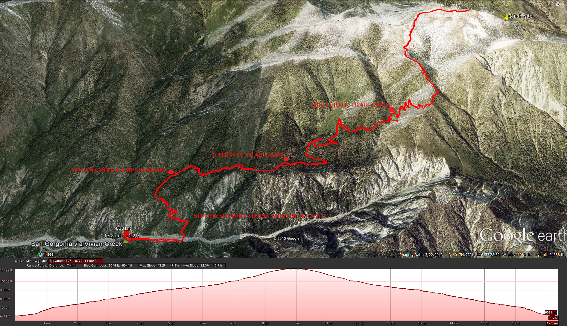
Distance: 17.3 miles
Elevation Gained: 5,300, with a top elevation of 11,502 feet.
Time to complete the trail: All day event, times will vary depending on your fitness levels.
Vivian Trail Head to Vivian Creek Camp 1.2 miles. Change of 1,120 feet. From 6,080 to 7,200 feet. ( water available)
Vivian Creek Camp to Half Way Camp 2.4 miles. Change of 900 feet. From 7,200 to 8,100 feet. (Water is obtained from the creek 200 yards before camp)
Half Way Camp to High Creek 1.2 miles. Change of 1,340 feet. From 8,100 to 9,440 feet. (water available)
High Creek to the San Gorgonio Peak 3.8 miles. Change of 2,062eet. From 9,440 to 11,502 feet.
For up to date water information check out this link: http://www.howlingduck.com/cgi-local/display_water_data.pl
Directions: To get here head towards Redlands, take the Orange Street Exit. Turn left head under the overpass until you hit East Lugonia Ave or highway 38. Turn right onto East Lugonia Ave or highway 38 and head up highway 38 towards Big Bear for 14 miles until you see the turn off for Forest Falls. Take the turn off and head up the road 4.4 miles until it ends at the Vivian Creek Camp Trail Head
Fees and Permits: A Wilderness Permit is required for this hike. as is an Adventure Pass
First lesson of the day, check the hiking trail status before you drive several hours to get there. I didn’t think about the government shutdown until I got to the trail head at 7:30 am and saw a sign telling me it was closed. Mind you this wont always happen, but other catastrophes may happen that close down the trail head and its better to check before you go, that being said I just drove back a mile or so to the trail head for the Monyer-Alger Creek Trail and walked through town to the get to the trail head. There was ranger at the gate, nice guy asked me where I parked, wanted to make sure I didn’t get a ticket, he was volunteering his time even though he was furloughed. Anyways the trail head starts at the very end of the campgrounds there, its probably never been so empty. Once you get to the trail head follow the trail (dirt road) until you get to the sign telling you to cross the wash, that wash must get crazy during the winter time. When you get to the other side just follow the signs and start heading up the trail. Think about the trail you are heading up for the first mile, I found it to be steep and slippery, not something I wanted to be coming down in the dark even with a headlamp. That first mile will kick your butt, after getting to the top of the ridge the trial evens out some. The trail will first meander through the Vivian Creek Camp ( your first source of water) and some beautiful forest. I found this trail to be really rough on the feet, I would not suggest hiking in anything less then hiking boots on this trail, the trail will vary between somewhat ok and rocky as hell, its just best to have good support for you feet. As you keep on the trail you will pass through a area with tall grass’s and ferns and then make you way towards the Halfway camp. At Halfway camp you will see a sign with one arrow pointing to the left for High Creek and one arrow pointing right for High Camp. If you want to camp at this point head down towards high camp, if not continue on towards High Creek. At this point the trail starts getting steeper and rockier again but you will see some great views. Eventually you will come to the High Creek Camp, when you see the sign for the High Creek Camp with an arrow pointing to the right, realize the trail is right behind that tree. High Creek Camp is the last place for you to fill up on water so I would suggest that you do so and have a break before moving on. Just after High Creek Camp are the switch backs. This is about as far as I got before I had to turn around and get back to my car before dark. When I get a chance I will head up and do this trail and complete this tale, for now this will have to do.
Weather Forecast for San Gorgonio via Vivian Creek


