
Heading up the service road along the backside of Mt Woodson. Mt Woodson Hike East Side Approach
Eastern Approach To Mt Woodson Peak
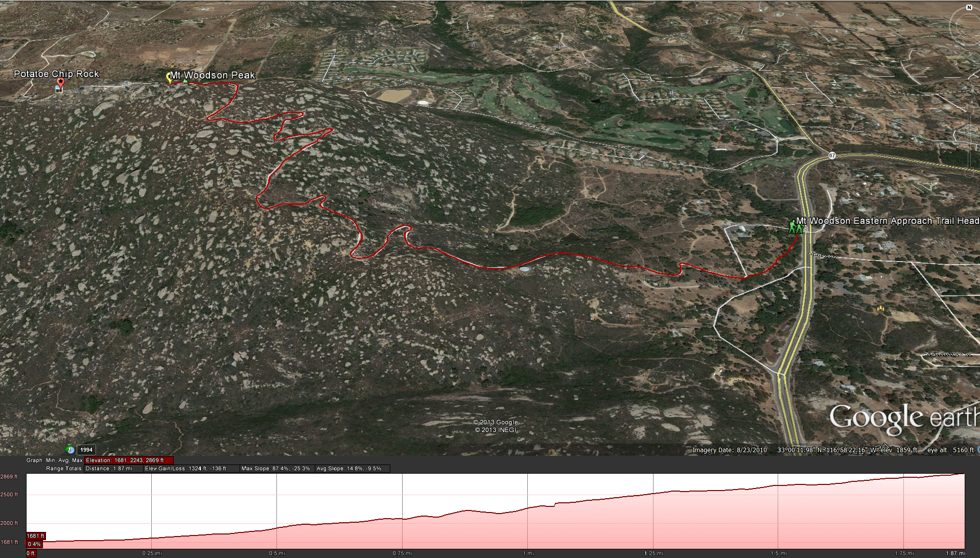
Google Earth: Mt Woodson Backside Trail
Distance: 4 miles up and back.Elevation Gain: 1500 feet. Time to complete: 1.5- 2 hours roundtrip
This a cool night hike as well. There is no parking, you just have to park on the highway, bring a headlamp or flashlight and make sure you have nothing visably sitting in your car that someone might want to break into your car for, but on the flip side you don’t need to worry about getting locked into the parking lot when they close the gates like they do on the front and its a much shorter hike.
Directions: To get to this hike you need to get to highway 67, you can get to highway 67 many ways but the easiest is to get off on Scripps Poway Parkway from the 15 and take it east until it meets the 67. Turn left and head north east towards Ramona. You will pass the trail head to Iron Mountain on your right and the end of Poway Road on your left, keep going past this point for another mile or 2, you will wind up the mountain and as you come down look towards your left ( west ) and you should see a bunch of cars parked along the road ( unless its really dead that day), there is no parking lot so take a left into the fire station road, do a U-turn and go back out and park on the road. Make sure you hide any thing valuable in your car. The trail head has a sign near the Fire Station Road.
Take the trail from the fire station road and head southwest towards the mountain, you won’t be on the trail for long, soon you will come across a service road, take a right on the service road and head towards the mountain. The service road will wind its way past a few houses and then start a slow steep climb up the mountain, you will pass a water tank and then the road will start to wind about. Take a breather every once in a while and look behind you at the Ramona Valley, its a pretty site. As you continue to go up you will start to pass by larger and larger boulders, this is a popular spot for bouldering http://www.mountainproject.com/v/mount-woodson/105791148, many times as I head up this road I’ll see a couple of people heading up the trail with large cushions strapped to their backs as they go looking for some adventure. Eventually you will come to a point in the road where it starts to head more north and south, about this point you will start to see views looking down towards the 67 and Iron Mountain towards the south west, on clear day you can see all the way to downtown. You will continue to meander up the mountain, with your view of Ramona Valley extending further and further, eventually you will reach the top of the mountain. Its easy to figure out, its where all the antennas are at. You will have some pretty cool views from here, but if you want to get to Potato Chip Rock, start heading down the other side of the mountain ( not long , don’t worry) and you will get to it in no time, if its a busy day you will see a line of people waiting to get up there and take their pictures, if its a slow day you may get it all to yourself. Enjoy the beauty.
Weather forecast for the hike:
[forecast location="92065" caption="Weather for Mt Woodson Eastern Approach" measurement='F' todaylabel="Today" datelabel="(%%weekday%%)"highlow='%%high%%°/%%low%%°' numdays="5" iconset="Contemporary" cache="true" width="100%"]
Pictures from the hiking trail:


