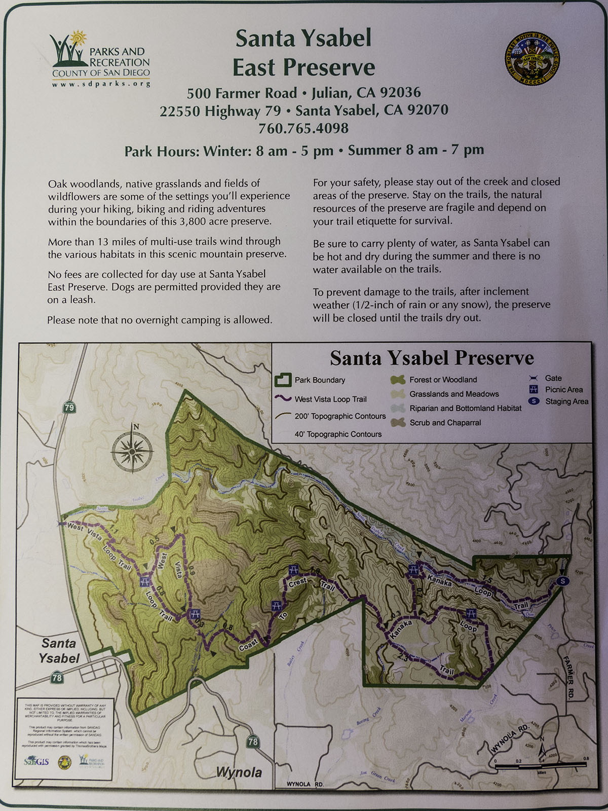
I like this map that is provided for you at the trail head. There always seems to be a good supply of them at the trail head but I thought I would provide it just in case.
Santa Ysabel East Preserve Map PDF:
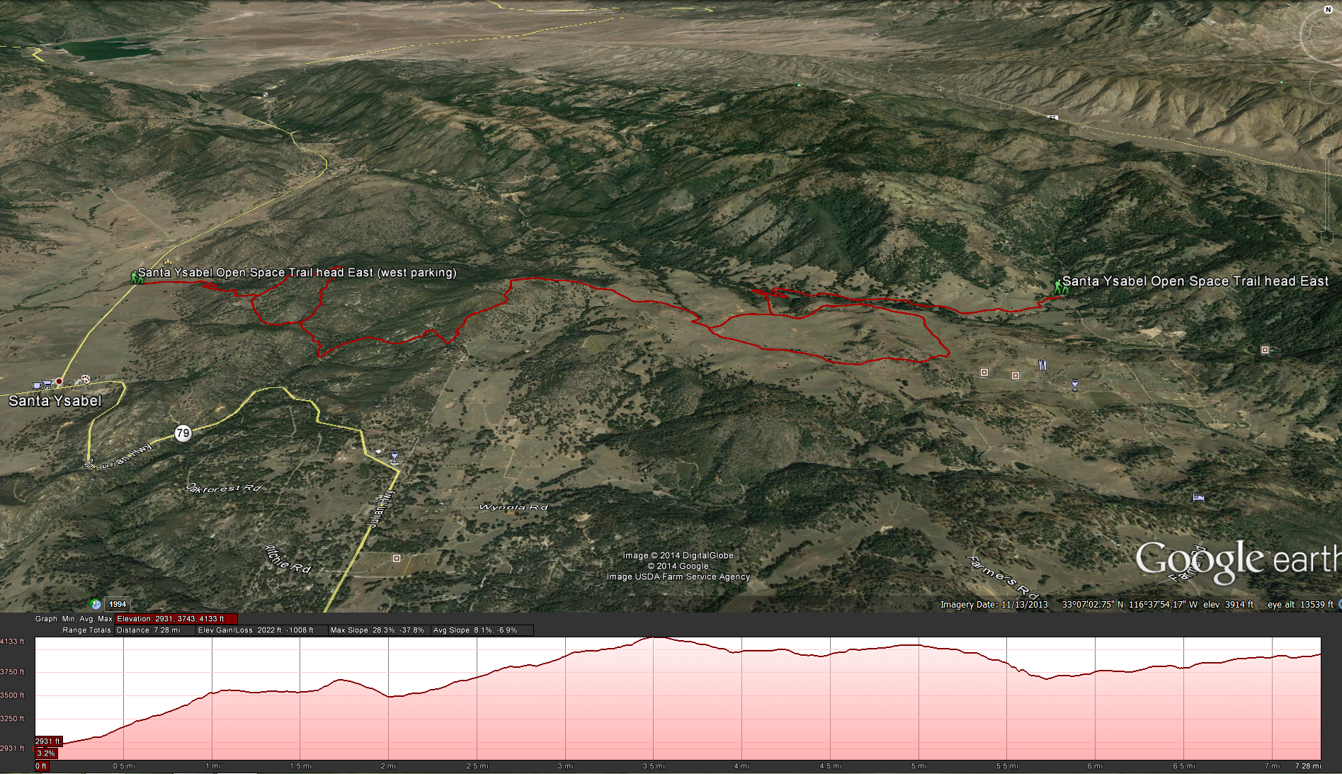
Google Earth: Santa Ysabel Eastern Preserve TrailDistance: 7.4 miles without the loops, 10 miles with the loops ; West Loop is 1.3 Miles, & Kanaka Loop is 2.3 miles .Elevation Gain: 1200 feet. Time to complete: 3-4 hours 1 way point to point.
How to get there:
Santa Ysabel East Trail Head ( west side) Hwy 79: This trail head is situated on Highway 79 about 1.2 miles north of the Hwy 78 and Hwy 79 junction where Dudley’s and the Julian Pie Company are. There is some area to park on the side of the road, but no designated area.
Santa Ysabel East Trail Head ( east side ) off of Farmers Road: This trail head is on Farmers Road close to the trailhead for Volcan Mountain. Take Highway 78 towards Julian. As you are getting close to the town of Julian from the west you can take Wynola Road, right next to Jeremy’s on the Hill. Take a left onto Wynola Road and follow it down into a little valley until you can turn left onto Farmer Road, about 1.3 miles down the road you should see the trailhead on your left side.
Either way you go this is a nice trail but I prefer hiking from west to east as this way has a gradual uphill climb of about 1200 feet from the western trail head to the eastern trail head. Not to far after you cross the gate of the western trial head you will start making your ascent, there are a couple of good steep climbs in the beginning, but once you make it up to the next gate it starts to even out a little. At this point you will start strolling through some of California’s famous oak trees. One member of my hiking group commented and I agree with her that this area reminds me of the rolling golden hills covered in oak trees in northern California. You will be on the trail for about 1.1 miles before you see the fork in the trail for the Western Loop trail. Take a left and you will go around the Western Loop Trail before you connect back into the Coast To Crest Trail, The Western Loop trail is 1.4 miles before it connects back into the Coast to Crest, the Coast to Crest Trail segment before you hit that same junction is 0.8 miles, so taking the western loop only adds 6 / 10 of a mile to your hike but its worth it, very pretty. Once you hit that junction you will continue to climb for a little bit and then drop back into a small valley before climbing a little to hit the next junction about 3 miles down the trail. At the next junction you will get to decide if you want to go right and head through the cow pasture and counter clockwise onto the Kanaka Trail Loop which adds about 2.3 miles to the hike or take a left and continue on the Coast to Crest trail for another 0.3 miles before you hit the next junction where Kanaka Loop connects back into the Coast to Crest trail system, I would suggest that you take the loop, it makes for a nice little extra section of the hike with a good view of Volcan Mountain in the east, Palomar Mountain the the Palomar Observatory in the north west, and El Cajon Mountain in South West. Watch out for the cow bombs on this trail and you may have a cows wandering around in your path, but they are pretty benign. At the end of the Kanaka Loop you will head back down hill connect back into the Coast to Crest trail and continue to head down hill into the valley before you cross a creek and head back along the trail through some grass fields and connect with the Eastern Trail head.
[forecast location=”92070″ caption=”Weather for Santa Ysabel Eastern Preserve Hike” measurement=’F’ todaylabel=”Today” datelabel=”(%%weekday%%)”highlow=’%%high%%°/%%low%%°’ numdays=”5″ iconset=”Contemporary” cache=”true” width=”100%”]


